Locations Editor
Every study needs a location, and event dates are reported in that location's time zone, so the places a researcher works with are worth setting up once and having available everywhere. The Locations Editor is where that list is built: it holds the locations that Aquila's Location drop-downs offer, in an editable table with Name, Latitude, Longitude and Height (feet) columns.
Only the coordinates have to be entered. Aquila resolves the correct time zone from them and applies the historical daylight-saving rules in force for any date, anywhere in the world, so no time-zone field appears in the table. The location list is stored outside any one workspace and is shared with the other Rhythm Seven astrology applications, so a place added here is available to all of them.
Open the Locations Editor
To open the editor:
- Open the Edit Menu.
- Click Locations in the Edit menu.
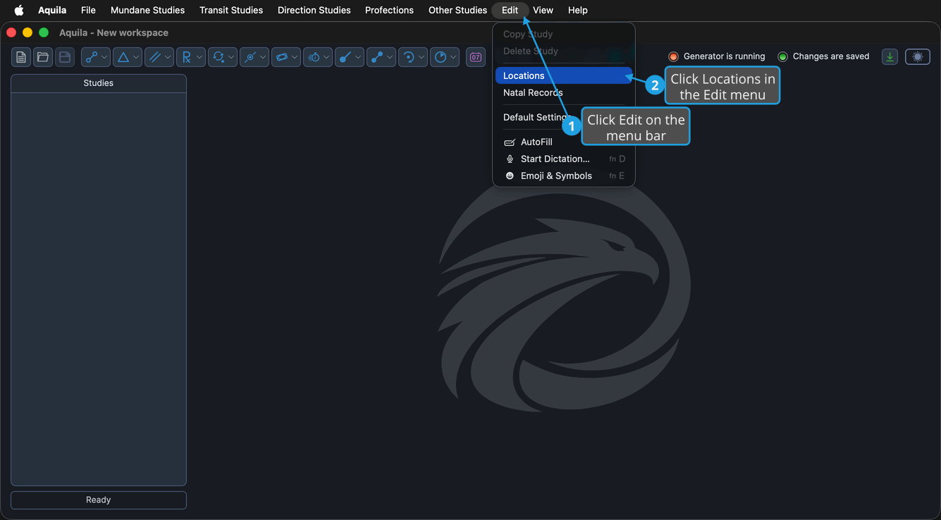
The Locations toolbar button on the main window opens the same editor in a single click.
The Locations Table
The table holds one row per location and always shows the same four columns.
| Column | Description |
|---|---|
| Name | The location's name, as it appears in every Location drop-down in the application |
| Latitude | The location's latitude in degrees, positive north |
| Longitude | The location's longitude in degrees, positive east |
| Height (feet) | The location's elevation in feet |
No column can be sorted by clicking its column header. Rows are added and removed with the Add and Delete buttons below the table rather than by typing into a placeholder row.
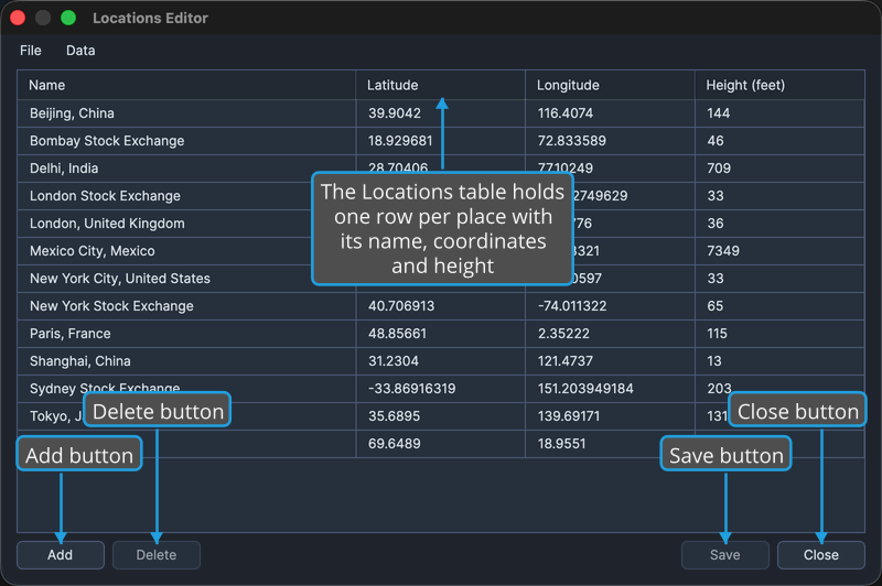
Add a Location
To append an empty row so a new place can be entered:
- Click the Add button below the table.
Aquila appends a new row to the table and puts it into edit mode, with its Name cell ready for typing.
Edit a Location
Cells are edited in place. The gesture is two single clicks, never a double-click: click the row to select it, then click the cell to open its editor. The row stays in edit mode until focus leaves it, so several cells in the same row can be filled in one pass.
To change any value recorded against a location:
- Click the location's row to select it.
- Click the cell you want to change to put the row into edit mode.
- Type the new value and press Tab or Enter to commit the edit.
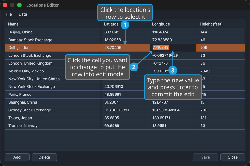
The columns take a place name, a latitude and longitude in degrees, and an elevation in feet, as the column table above sets out. Every edit marks the editor as holding unsaved changes until you save the list.
Enter commits the value in the cell it was typed into. Tab commits it and moves on to the next cell in the same row, which is the quicker way to fill in a new location's name and coordinates in one run.
Delete Locations
To remove one or more places from the list:
- Select the rows to remove in the Locations table.
- Click the Delete button below the table.
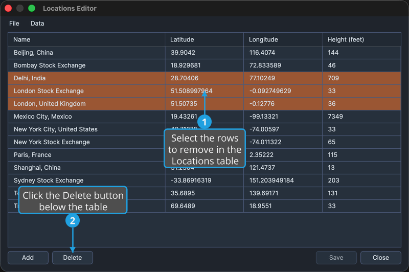
Cmd-click to toggle individual rows in the selection; Shift-click to extend the selection to a range. On Windows use Ctrl-click in place of Cmd-click.
Pressing the Delete key removes the selected rows as well, as long as the table holds keyboard focus.
Save the Location List
To write the edited list back to the shared store:
- Click the Save button at the bottom-right of the editor.
Aquila writes the list outside the workspace, where the other Rhythm Seven astrology applications can see it, and the editor stops showing unsaved changes. Save is also available from the editor's File menu and is bound to Cmd+S (Ctrl+S on Windows). It is unavailable while there is nothing to save.
Close the Editor
To leave the editor and return to the main window:
- Click the Close button at the bottom-right of the editor.
Exit on the editor's File menu and the window's own close button do the same thing.
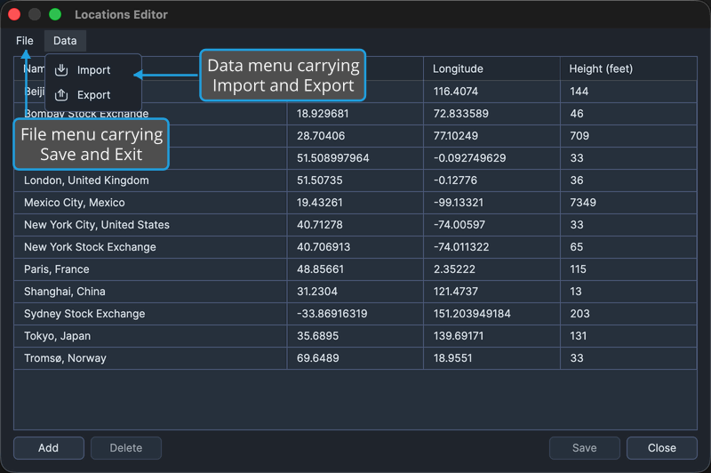
The Editor Menus
The editor carries two menus of its own above the table.
| Menu | Command | Description |
|---|---|---|
| File | Save | Writes the list back to the shared store, the same as the Save button |
| File | Exit | Closes the editor |
| Data | Import | Adds locations read from a file to the list. See Import Locations |
| Data | Export | Writes the whole list out to a file. See Export Locations |