Height Above Sea Level
Two angles fix a direction from the centre of the Earth. They do not fix how far along that direction you are standing — and there is room to differ, because the ground is not all the same distance from the centre.
The third number closes that gap. Height above sea level, also called elevation, says how far out along the same line you sit. It is the one genuine distance in a location, which is why it is kept apart from the two angles rather than treated as a third coordinate of the same kind.
Going up changes neither angle
A summit and the valley floor beneath it can share a latitude and a longitude, and "straight up" points the same way at both. You have moved along the radius, not around the sphere.
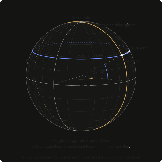
This is the previous page's figure rebuilt on Mount Everest — the same two reference circles, the same two angles, swung the same way. Everest's longitude is the 87° measured east along the equator from the prime meridian; its latitude is the 28° measured north up its own meridian. Everest is used because it is the highest point on Earth, so whatever its height leaves unchanged, no smaller height will change either.
The one addition is the white stub past the surface, and that is the height. It leaves both angles exactly as they were, so the point marked at sea level and the summit above it have the same latitude and the same longitude — the highest place on Earth and the rock five and a half miles beneath it, down where sea level would be, are named by the same two numbers.
The figure exaggerates the height about a hundred and fifty times over, because it has to: drawn to scale, Everest would be thinner than the line marking the surface. Hold on to that, because it is the reason height changes as little as it does.
What "sea level" means
The Earth is neither smooth nor perfectly round. It bulges at the equator by about 21 km, and the sea itself is not a tidy shape. "Sea level" is therefore a chosen reference surface, continued in imagination beneath the continents, with heights quoted above it.
That choice is why two sources can disagree about the same summit by as much as a hundred metres: a satellite receiver naturally measures against a smooth mathematical figure of the Earth, while a map quotes mean sea level. The difference does not matter for anything on this site. It is worth knowing only so that a disagreement between two gazetteers does not look like an error in one of them.
A word already spoken for
Elevation is often called altitude — in aviation, almost always. This site never uses it that way. Here altitude means the angle of a body above the horizon, the measurement introduced in The Horizon.
When this site says altitude it means an angle in the sky. When it means a height on the ground, it says height or elevation.
What height changes, and what it does not
Very little, and that follows from the figure above. Everest stands about one part in seven hundred of the Earth's radius, so whatever height does, it does at that scale.
It lowers the horizon you can see. From high ground you see slightly past the point where the ground would cut off the view at sea level, so the visible horizon sits a little below the true one. Denver's mile drops it by about 1.3°, which brings sunrise forward and pushes sunset back by six or seven minutes. The true horizon has not moved; the horizon you can see has. That is the distinction drawn in The Horizon.
It shifts the Moon, very slightly. Standing on the surface rather than at the Earth's centre moves the Moon's apparent position by up to about a degree. Height adds to that in proportion to how far it lifts you clear of the surface, so Denver's mile is worth just under an arcsecond. That effect is parallax, and it is the whole subject of the Coordinate Origins category.
It leaves a chart's angles alone. The Ascendant, the Midheaven and the house cusps depend on which way is up and on how the sky is turned, and height changes neither. A chart cast for the summit and one cast for the valley agree.
Where it is used
Height is entered alongside the two angles, positive upwards; the handful of inhabited places below sea level take a negative number. A mistake here does not matter the way a wrong longitude sign does, because an error of a few hundred feet makes no visible difference to the output.
It is used when positions are measured from a topocentric origin — that is, from where the observer is standing rather than from the centre of the Earth — and in the handful of calculations where a little extra height makes a real difference, such as the circumstances of a solar eclipse or the first and last visibility of a body in twilight.
Everywhere else it is carried in the record without affecting anything, which is right: at a scale of one part in seven hundred, there is nothing for it to change.
What comes next
The location record holds one more field, and it is not a measurement of the Earth. It records how people have agreed to set their clocks, and because those agreements have changed so often, it is the field where charts most often go wrong. The next page explains how.
Next: The Time Zone in a Location.