Latitude and Longitude
A place is named by a pair of angles called latitude and longitude, which together make up the geographic coordinate system.
Two angles, not two distances
It is natural to think of latitude and longitude as a grid, like the squares on a street map. That picture causes trouble later, so it is worth replacing now.
Latitude and longitude are angles, and both are measured at the centre of the Earth. A location is named not by how far it sits from somewhere else, but by the direction you would have to look, from the middle of the planet, to see it.
This matters because the same idea, naming a direction with two angles rather than a place with two distances, is how positions in the sky are described as well. Once it is familiar on a globe you can picture, the celestial version needs no new idea at all.
Measuring an angle requires something to measure from, so the system fixes two reference circles:
- The equator, the circle halfway between the two poles.
- The prime meridian, a half-circle running pole to pole, passing through Greenwich in London.
Both choices are conventions, though the equator is at least a natural one, because the Earth's rotation picks it out. The prime meridian is simply an agreement, settled by an international conference in 1884.
Latitude
Latitude is the angle north or south of the equator, from 0° at the equator to 90° at either pole. New York City sits at about 41° north — a little under halfway from the equator to the pole.
Every point sharing a latitude forms a circle running parallel to the equator, which is why such a circle is called a parallel of latitude. Parallels get smaller the closer they are to the poles, shrinking to a point at 90°.
Longitude
Longitude is the angle east or west of the prime meridian, from 0° to 180° in each direction. New York City is about 74° west — roughly a fifth of the way around the globe from Greenwich.
Every point sharing a longitude forms a half-circle from pole to pole called a meridian of longitude. Unlike parallels, all meridians are the same size, and all of them meet at both poles.
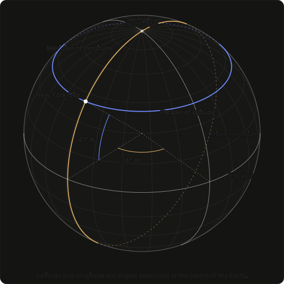
Read the diagram as a solid sphere. The two grey circles are the reference circles named above — the labelled prime meridian is longitude 0°, the labelled equator is latitude 0°, and both angles are swung from there. The gold meridian and blue parallel belong to New York City; each is solid where it faces you and dashed where it continues around the back.
The three dotted straight lines run from the centre of the Earth out to the surface — one to where the prime meridian meets the equator, one to where New York's meridian meets it, and one to New York City itself. The short coloured arcs between them are the angles: the first pair brackets 74° of longitude swung along the equator from the prime meridian, the second pair 41° of latitude swung up the meridian from the equator.
New York City is the point where those two circles cross, and every other location is found the same way: a latitude picks a parallel, a longitude picks a meridian, and the two cross at exactly one place.
Writing coordinates down
Two notations are in common use, and confusing them is a common cause of wrong charts.
| Location | Traditional | Signed decimal |
|---|---|---|
| New York City | 40° 42′ 46″ N, 74° 00′ 22″ W | 40.7128, −74.0060 |
| Denver | 39° 44′ 21″ N, 104° 59′ 25″ W | 39.7392, −104.9903 |
| Sydney | 33° 52′ 08″ S, 151° 12′ 33″ E | −33.8688, 151.2093 |
The traditional form divides a degree into 60 minutes of arc (′), and each minute into 60 seconds of arc (″), then states the hemisphere as a letter. The decimal form folds the hemisphere into the sign of the number: north and east are positive, south and west are negative.
Signed decimal is the form most software expects.
The trap is longitude in the Americas. It is west, so it is negative. Entering New York as +74 rather than −74 places it in western China, and the chart that results is wrong while still looking plausible.
Nothing in the output shows the mistake. The planets are where they were, and only the parts of the chart that depend on the ground beneath you have changed: they now describe somewhere else.
What each one decides
The two angles do different kinds of work, and the rest of this category is built on that division, so it helps to name it early.
Latitude decides what sky you get. It fixes how the sky is tilted above you, which part of it never sets, which part never rises, and how steeply bodies climb when they do. Move north or south and the sky changes shape.
Longitude decides when you get it. It fixes what time it is where you stand, and therefore which part of the sky is overhead at any given clock reading. Move east or west and the same sky arrives earlier or later.
Latitude is taken up in How Latitude Tilts the Sky at the end of this category. Longitude's effect on the clock begins in The Time Zone in a Location.
What comes next
Two angles fix a direction from the centre of the Earth, but not how far out along that direction you are standing. A location record carries that as well, and the next page describes it.
Next: Height Above Sea Level.