Why a Chart Needs a Place
The Location setting comes first, above the zodiac, the origin and the plane, because almost everything an ephemeris calculates depends on it.
It is easy to think of a location as a label: a note of where something happened, the way a photograph carries the name of the town it was taken in. But a location is an input to the calculation, and changing it changes the answer.
The same instant, two skies
Suppose two people look up at the same moment, one in Paris and the other in New York. They are looking at the same universe at the same instant, and yet they do not see the same sky.
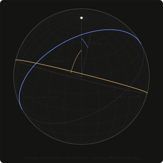
The diagram shows one star at one moment, and two observers, each with their own horizon. For one of them the star stands 55° above the ground; for the other, 20°. Neither of them is wrong. The star is in one place, and they are measuring its height from two different floors.
Move the two observers further apart and the disagreement grows. Eventually it is no longer about how high the star stands but about whether it is above the horizon at all. At the same instant that a star stands high over Paris, it can be entirely below the horizon in Sydney, on the other side of the world, where nobody can see it.
What the place actually supplies
A location is three numbers and a name, and one further thing that follows from them:
| What it is | What it fixes |
|---|---|
| Latitude | how the sky is tilted, and which parts of it you can ever see |
| Longitude | what time it is where you are, and which part of the sky is overhead |
| Height | almost nothing — and knowing that is worth as much as the rest |
| Its time zone | how the clock reading in the record converts to a real instant |
The first three are entered, and the fourth is not. Which time zone a place keeps is a fact about the place, so it follows once the coordinates are known.
The next four pages take these one at a time. The pages after them turn to the consequences: what your place fixes overhead, and what changes as you move across the Earth.
One place, used everywhere
A location is entered once and then used throughout: in every chart, every calculation and every default. It fixes when the moment is, which way is up and what is overhead, and it does all three whichever origin the chart is measured from. Only under Topocentric does it also become the point from which the measuring starts.
What comes next
Before a place can be used it has to be named precisely, and a name such as "New York" is not precise enough. The next page describes how a place is fixed exactly, by a pair of angles.
Next: Latitude and Longitude.